Wednesday, May 2, 2012

Final Days in Tanzania...


The Final Assessment:  Geographic Tanzania in the Future

Tanzania can boast of a diverse and unique physical geography examples of which we have discussed in our blog.  The mainland is a part of the Great Valley Rift which is a continuous geographic trench (3700 miles). This chasm is caused by movement of the tectonic plate.  The illustration below illustrates the same rift that helped define the Tanzanian geography.  Rifts are usually preceded by huge volcanic eruptions such those from Ngorongora and Mt Kilimanjaro.  These geological actions created the backflows for the formation of Lake Victoria.  Each action (process) resulted in a reaction (form) that created new geological constructs.


East Africa's Great Rift Valley: A Complex Rift System by James Wood and Alex Guth Michigan Technological University.


Geological formations in the Great Rift Valley of Tanzania


The Same Actions Get the Same Results

If left unchecked, our disregard for the natural balances in nature may be the most critical factor affecting the rate at which geographic changes occur, and then negative changes which would have normally occurred over a longer period of time will be exponentially accelerated.   Information considered when developing support for the hypothesis include: Warming of the Indian Ocean (3.6 degrees in 40 Years), severe droughts and floods in 2012, CO2 concentration in the atmosphere at 280 parts per million, and changing weather patterns.
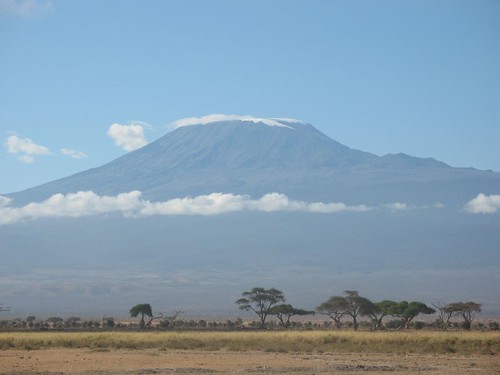
Landscape Tanzania 2021:  Kilimanjaro already having lost 80% of its ice pack will be devoid of glaciers and snow.  Coastal regions will see slight increases in coastline erosion due to rising ocean water levels and inland lakes will receive more precipitation. Drought and flooding will become more severe increasing soil erosion. Average temperatures will hot affecting  all living things. Migrating animals will find less fertile pastures.  Ngorongora crater will see a slight loss of plant life in the low lying valley, but the Dodo Region will be more desert like. 

NASA Earth Observatory Photo illustrates the receding snow and glacial ice on Kilimanjaro in 2009.


Droughts are so severe wells are dug deeper and deeper as seen of the woman exiting one in the above photo.  This was not mitigated in 2012.


Landscape Tanzania 2112:  The circumstances in 2112 are those of 2021 magnified by 10.    Additional concerns are the Indian Ocean rises robbing the coast line of as much as ten feet of land,  coastal islands begin to disappear,  basal weathering accelerates eroding lake islands, and  deforestation caused by nature are compounded in the quest for new farm land.  Forests, natural reabsorption agents for CO2 , are lost in the quest to grow food.  Arid lands become more desert like.  The DoDo Region is rutted with gullies from flood waters that come with the torrential rains.  Winds create tornado like storms there. Ngorongora has becoming  marsh land as the water comes in and has no outlet. 

Landscape Tanzania 3012:  21th century heat waves increase the average temperature by 6.4 degrees based on our current 1.4 degree increase every 230 years.  Ngorongora is a lake.  Islands off the coast are covered with ocean water which has moved inland 23 feet due to the changing  hydrologic cycle, increased ocean temperatures and trade winds.  The coral reefs  are gone.  The country is plagued by wildfires, heat waves and tropical storms.  Carcasses of animals litter the land.  Plant and animal life have either adapted or become extinct. Lush green lands are few. 

Climate is temperature, humidity, wind and precipitation all of which are affected by the land’s latitude, terrain, altitude and bodies of water. Tectonic plate movement and volcanic eruption change the topography of the land and the climate. The eruption of Mount Tambora produced a year without a summer.  If these events occurred with global warming, it could well impact the earth for tens of thousands of years. 


Weather systems and climate changes have always occurred but usually over hundreds of thousands of years and were not created by changes outside of nature.


This is no ordinary storm in the scenario of climate change created by global warming. Lightening, tornados, mega rain are hidden in the clouds.


References

Chanton, Jeffery. "Global Warming and Rising Oceans." Actrionbioscience.org. Actionbioscience, Sept.-Oct. 2002. Web. 27 Apr. 2012.

Duncan, Sandi. "How Do Volcanos Affect Our Weather?" Farmersalmanic.com. Sept.-Oct. 2009. Web. 28 Apr. 2012.

"Geography of Tanzania." Www.howstuffworks.com. Web. 27 Apr. 2012.

Holman, Teresa. "The Effects of Global Warming on Continental Oceans." Www.ehow.com. May 2011. Web. 28 Apr. 2012. <27>.


Woods, James, and Alex Guth. "East Africa; Great Rift Valley: A Complex Rift System." Geology.com. Web. 28 Apr. 2012. <http//gelogy.com>.


Thursday, April 12, 2012

Tanzania- most excitement


The Power of Wind and Rain


Wind is a powerful element as we can see from the impact it has on the weather in Tanzania. The Chart depicting the rainfall in Arusha is indicative of the power of the wind. Wind effects result in three major weather forms. Monsoons have become synonymous with continuous heavy rainfall which is the 
form that results from the process of winds interacting and the resulting changes in temperature in the atmosphere. A Monsoon is wind that blows regularly in a definite season. These winds create atmospheric changes which produce (1) heavy downpours which the earth cannot absorb immediately (floods), (2) continuous long periods of moderate rainfall (monsoons), (3) and the absence of rain (droughts or dry monsoons) for extended periods. These three weather forms are the result of one process: the pattern of winds.
        The Bordonis of the Center for Atmospheric Research in Colorado, through computer modeling, illustrated that mixing tropical air with large scale turbulence in the middle latitude causes rapid circulation changes, high surface winds and heavy rainfall occurs in the absence of land--monsoon condition without hot air from land masses. Conduction and radiation of air molecules are keys in this process. This weather pattern is characteristic of the savanna in Tanzania. We can see the rain coming to the plains.


While traveling through Serengeti, we took a picture of these beautiful clouds which are characterized as Nimbostratus. These types of clouds are a sign of steady, moderate, or heavy precipitation. Nimbostratus clouds are low-level clouds that are formed between earth's surface. While doing research we found that the clouds are formed when the sun heats the surface of the earth. The air that is near the earth's surface absorbs the heat as it rises from the ground and the rest of the air keeps rising. Looking at the shape of the clouds you can see that it doesn't really have a form, it is flat and layered. This shape identifies as a stratus cloud. In the photo above you can see that the clouds are a little bit of a dark grey color. When the presence of the dark grey color appears there is moisture in the cloud. As you can see above, there is a little moisture in the clouds because they are a light grey not a dark grey.  If the clouds appear very dark, it is likely to rain or even snow. 

Tornadoes are common in the United States.  In Tanzania, they have a miniature version of  these storms.  They are what we would call large dust devils.  They are formed when  hot and cold air collide, but  because the temperature variance is not as great as in the States they are usually harmless.  This rotating updraft, formed in sunny conditions, is an unusual weather phenomenon of swirling air vortices. 


Thursday, March 8, 2012

Weathering


         Kondoa and Lake Victoria are two areas which illustrate of the following processes: water and wind erosion, pressure release (tectonic activity), basal weathering, and hydrologic cycle.

Kondoa, Dodoma Region, Tanzania
            Looking at the picture this form shows soil erosion. Soil erosion is a naturally occurring process on all land. The agents of soil erosion are water and wind, each contributing a significant amount of soil loss each year. When the water impacts the soil surface, it breaks down and the materials disperse. In this picture it clearly shows where the land was previously and where it is now, indicating that erosion has occurred over the years. Kondoa is characteristically associated with grasslands, the steppes and semi-deserts. Here we see evidence of Calcification, is a pedogenic regime of climates in which evaporation on the average exceeds precipitation, revealing thick roots of perennial grasses and a more drier look.
.
 Lake Victoria, Tanzania


Hydrologic Cycle:
Lake Victoria is the largest lake on the Continent of Africa, fifty-one percent of it shoreline and volume within Tanzania.  This Lake is believed to have been created by the upheavals on the western side of the Victorian Basin.  This dam of crustal rock blocked westward flowing rivers which caused the rivers to flow backwards away from the basin.  After this process the lake is resulted as being shallow 250 miles long and 200 miles wide with 3,440 feet of shore line. With limited river inflow, Lake Victoria is dependent on the hydrologic cycle, which replenishes its waters. 
Cycle Picture: 


Tanzania is located on the coast of the Indian Ocean, making that ocean the primary source for its water.  The water evaporates from the Indian Ocean it rises quickly into the atmosphere and condenses.  The condensed water becomes clouds and is carried by wind inland.  The clouds produce rain which maintains the lake's level, fills rivers which flow back to the ocean.  The cycle repeats itself and the water levels are maintained.  


Basal Weathering/Water & Wind Erosion: 

Yes, we as people will see the beauty of nature in this photograph, but we looked at is as geographers. The effects of erosion can be seen in the rock formation. The outcrop of boulders appear to be smooth. Natural weathering from rain and wind are the major contributors to the resulting form of the boulders. Upon close examination, we would undoubtedly see basal weathering, the erosion of the rock at its base and on the rock outcrop.  These rock formations are prevalent in the lake as are islands of varying sizes.  The islands also are likely created from the  high basal friction and compression in the plate tectonics associated with the creation of the lake.
Conclusion: 
Lake Victoria is critical to the socio-economic structure of the region.  Not only is revenue generated by tourism and resident vacationers, the lake and its basin have many natural resources which have industrial and commercial application. There is gold mining, fisheries and coffee and cotton production.  It is a major water source for domestic, industrial and commercial enterprises.  Geography can be changed by man as well as nature.  There are indications that man is changing the lake's geography and not in a positive manner.  The people must insure that the costs of changing what nature has given them do not out weigh the benefits.  


Monday, February 13, 2012

As We Continue Our Journey

NGORONGORO CRATER

Ngorongora Crater is the largest unbroken volcanic caldera, a collapsed volcano, in the world.  Calderas are classified as extreme volcanos. They are extremely powerful and catastrophic.  Formed by geological faulting, it is 259 square kilometers with walls over 600 meters high.  As a volcano, it was estimated to be larger than Mount Kilimanjaro.  The withdrawal of lava caused it to collapse, creating the crater that exist today.  The video below illustrates how a caldera is formed.


Demonstration Video: How Exactly is a Caldera formed?


Picture 1
Tanzania is the home of one of the world's greatest attractions, a large cinder cone volcano and a large dormant volcano crater known as Ngorongoro.  This large cinder cone volcano was formed roughly two to three million years ago.  Violent eruptions shot large amounts of lava and ash into the air, allowing lava to flow down the side of the volcano, and it creating smooth cliffs on the side of the crater.  After numerous eruptions the volcano grew in size creating a mountain uplift and evidence of lava flow that created this mountain as seen in picture one.  

Picture 2
Black Circle
Picture 3
  In pictures two and three, we can see the effects of basalitc lava flow. When a volcano erupts, pressurized magma forces its way out of the mountain at its highest peak, allowing the magma to seep through other cracks on the earth's mantal.  When fluid basalt flows, it can be extremely violent traveling tens of kilometers away from an erupting vent. When the lava flows over the land, it cools creating a smooth landscape. Basalt is the hard black rock formed from the basaltic lava.  Evidence of the lava flow can be seen in the landscape by the smooth texture seen on the mountain.  Minerals from the Earth, as well as ashes from the eruption, fertilizes the land.  Over time this violent, destructive event produces land that is abundant with a variety of plant life and creates an environment prosperous with wild-life.  


In the picture below we can see evidence of the formation of rills and gullies.  Rills are created from small channels of water traveling down the slopes of the volcano.  Gullies are formed by larger bodies of water eroding the mountainside as it travels down the slopes.  Gullies can form independent sources of water or form from a collection of rills.  This beautiful landscape is the result of water eroding the slopes of the volcano.


Ngorongoro Crater 

Saturday, January 21, 2012

The Beauty of Tanzania


Hello Everyone Wardell & Patrice here! Welcome to our blog!
We have decided to enlighten you about the country of Tanzania. We chose this country because of our extreme interest in Africa.  I,(Wardell) have had the opportunity to visit this country, giving us some first hand knowledge. From my experience, I learned that Tanzania has many geographical landforms that everyone may find extremely interesting. We are currently not geography majors but we are hoping to learn more about it, as well as how the Earth works the way it does. Looking at the picture above we truly think that Tanzania is a beautiful place and want to learn more about its geographical features.
The ability to connect what we learn in this class, will only help us to better understand the wonders that make Tanzania special.  From Mt. Kilimanjaro and Ngorongro to the beaches of Kunduchi, we hope to learn as much as possible. So with that being said, we would like to share with you EVERYTHING that we find!